WASHINGTON — Can a combination of crowd-sourced photography and smartphone software improve air defenses? The U.S. Army is willing to find out.
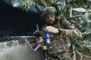
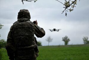
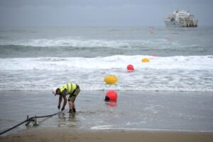
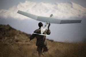
In trials earlier this month, soldiers in South Carolina used government-issued phones to capture and share images of a drone overhead using a nascent application known as CARPE Dronvm.
The app is funded by the Department of Defense and built by the Mitre Corporation, a manager of federally funded research and development centers. It is the brainchild of U.S. Air Forces Central, or AFCENT, which sought to more easily detect and tack airborne threats. U.S. Army Central, or ARCENT, is spearheading testing among troops.
“Countering the drone threat in the U.S. Central Command area of responsibility is essential to keeping our personnel, aircraft, and equipment safe,” Lt. Col. Steven Norris, AFCENT’s counter-UAS cell chief, said in a statement July 18.
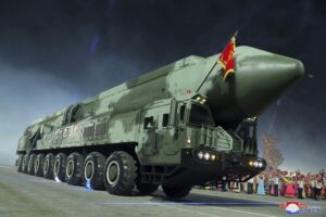
CENTCOM comprises more than 4 million square-miles of land, including Afghanistan, Iran and Iraq. The command in January said Iran attacked a base in Syria used by U.S. and local forces with three drones. Two were shot down.
“Every single warfighter can help sense and warn, creating a comprehensive layered defense that will tie into our existing command and control architecture and increase awareness of threats in the region,” Norris said of the app.
RELATED
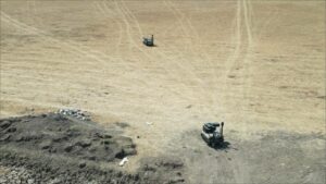
The dangers posed by unmanned aerial systems have mushroomed in recent years; drone strikes are near-synonymous with the Russia-Ukraine war, as both sides try to reconnoiter and attack from safer distances.
The Pentagon in 2019 established the Joint Counter-Unmanned Aircraft Systems Office to address the proliferation. There’s also the Rapid Capability and Critical Technologies Office, which is exploring the application of directed energy to zap drones midair.
“The UAS threat is a shared security challenge for the U.S. and our regional partners,” Lt. Gen. Patrick Frank, the ARCENT commander, said in a statement. “The advanced measures we intend to pursue regarding innovation and experimentation will provide critical, real-time data to inform Army and defense decisions on counter-UAS technologies.”
The CARPE Dronvm testing this month spanned some 31 miles, touching the McEntire Joint National Guard Base and Poinsett Range. Soldiers with the app were scattered across the area.
Officials described it as the largest evaluation to date.
“This was all to prove the CARPE Dronvm app works,” Maj. Travis Valley, with ARCENT’s Task Force 39, said in a statement. “It did. In fact, it exceeded my expectations on the simplicity of use and the program’s drone detection ability.”
Colin Demarest is a reporter at C4ISRNET, where he covers military networks, cyber and IT. Colin previously covered the Department of Energy and its National Nuclear Security Administration — namely Cold War cleanup and nuclear weapons development — for a daily newspaper in South Carolina. Colin is also an award-winning photographer.
- SEO Powered Content & PR Distribution. Get Amplified Today.
- PlatoData.Network Vertical Generative Ai. Empower Yourself. Access Here.
- PlatoAiStream. Web3 Intelligence. Knowledge Amplified. Access Here.
- PlatoESG. Automotive / EVs, Carbon, CleanTech, Energy, Environment, Solar, Waste Management. Access Here.
- BlockOffsets. Modernizing Environmental Offset Ownership. Access Here.
- Source: https://www.defensenews.com/unmanned/uas/2023/07/21/need-better-drone-defense-the-us-military-may-have-an-app-for-that/
- :is
- :where
- 1
- 11
- 2019
- 31
- 70
- a
- ability
- across
- address
- Adds
- administration
- advanced
- AFGHANISTAN
- AIR
- aircraft
- All
- also
- among
- an
- and
- app
- Application
- ARE
- AREA
- Army
- AS
- At
- attack
- award-winning
- awareness
- base
- Better
- both
- Both Sides
- built
- by
- CAN
- capability
- capture
- cell
- Centers
- central
- challenge
- chief
- cold
- collects
- combination
- comprehensive
- comprises
- control
- CORPORATION
- coupled
- covered
- covers
- Creating
- critical
- cyber
- daily
- dangers
- data
- Date
- decisions
- Defense
- Department
- department of defense
- Department of Energy
- described
- Detection
- Development
- DID
- down
- drone
- Drones
- during
- Earlier
- easily
- energy
- equipment
- essential
- established
- Ether (ETH)
- evaluation
- exceeded
- existing
- expectations
- Exploring
- fact
- false
- federally
- Find
- For
- Force
- Forces
- from
- funded
- Gen
- Guard
- Have
- he
- help
- http
- HTTPS
- image
- images
- improve
- in
- Including
- Increase
- inform
- Innovation
- intend
- into
- Iran
- iraq
- IT
- ITS
- January
- joint
- July
- keeping
- known
- Land
- largest
- layered
- local
- manager
- May..
- measures
- Military
- million
- Month
- more
- my
- namely
- nascent
- National
- Need
- networks
- nuclear
- Nuclear weapons
- of
- Office
- on
- or
- our
- out
- partners
- patrick
- pentagon
- Personnel
- phones
- photographer
- photography
- plato
- Plato Data Intelligence
- PlatoData
- previously
- procedures
- Prove
- provide
- pursue
- range
- real-time
- real-time data
- recent
- regarding
- region
- regional
- reporter
- research
- research and development
- responsibility
- Russia-Ukraine War
- s
- safe
- safer
- Said
- scattered
- Screen
- security
- sense
- Share
- shared
- shot
- Sides
- simplicity
- single
- smartphone
- Software
- some
- sought
- South
- South carolina
- spearheading
- Statement
- steven
- Strikes
- Syria
- Systems
- Task
- task force
- Technologies
- Testing
- than
- that
- The
- The Area
- the joint
- this
- threat
- threats
- three
- TIE
- to
- touching
- trials
- try
- two
- u.s.
- us
- US military
- use
- used
- using
- Valley
- war
- was
- we
- Weapons
- were
- which
- Wikipedia
- will
- willing
- with
- works
- years
- zephyrnet