One of the largest sources of data is all around us—that is, geospatial data. This is information relating to the Earth’s surface, its climate, the people who live on it, its ecosystems and more. Geographic information systems (GIS) visualize and make sense of this data, helping people and businesses better understand the patterns and relationships of our world.
GIS perform spatial analysis of geospatial datasets—consisting of vector data (points, lines and polygons) and raster data (cells with spatial information)—to produce connected visualizations. These maps, graphs, statistics and cartograms display geographical features like location, natural resources, streets and buildings as well as demographics. In its most recognizable form, a GIS visualization is what you see when you route a trip on Google Maps.
Real-world applications of GIS
GIS technology provides insights that are key to many industries and disciplines.
Urban planning
Governments use GIS data and GIS-based solutions for urban planning: zoning and land use projects, natural disaster and health event response, roadway system and building design, utility distribution, energy production, and waste and resource management. For example, planners in fire-prone California use tools that incorporate remote sensing, vector data and satellite images to formulate disaster response plans and optimal placement of fire hydrants. And the State of Arizona uses GIS technology to manage its portfolio of over nine million acres of land.
Weather forecasting
As extreme weather events increase in intensity and frequency across the globe, planning and preparing for them is crucial for governments and organizations alike. Software solutions that combine geospatial data, GIS mapping and advanced environmental analytics enable organizations to make different types of weather-related data actionable. More accurate forecasts use real-time data and digital maps to help companies better predict and respond to weather events, reducing impacts to operations.
Enterprise decision-making
GIS software enables strategic business decisions in areas such as transportation and delivery management, real estate portfolio management, customer segmentation and more.
For example, companies use GIS technology to ensure resources, including equipment and employees, are where they need to be—in-house or off-property. Integrating GIS, artificial intelligence (AI), the Internet of Things (IoT), cloud and mobile technologies into field service management (FSM) makes the most current information available to field service technicians. Efficient field service management ensures technicians respond to and resolve customer issues quickly, reducing service downtime and costs while increasing customer satisfaction.
Agriculture
GIS technology makes productive, sustainable farming possible by providing accurate, comprehensive data. Insights pertaining to land changes affecting crop health and where certain crops will grow better help improve decision-making and make crop management more efficient.
For example, smallholder farms are critical for a secure global food supply but they’re also particularly vulnerable to weather-related and climate-related variables. A technical-based solution built by the Plan21 Foundation and IBM shows how insights from a variety of sources, including weather and agronomic data, helps farmers better adapt to climate change. Read more about the initiative here.
Additionally, IBM and Texas A&M AgriLife have created a tool to help improve crop management strategies. Low-cost sensors placed in the soil record moisture and temperature levels to provide insights into when and how much water crops need. The data from this soil and water analysis helps farmers improve yields while reducing costs and pollution runoff.
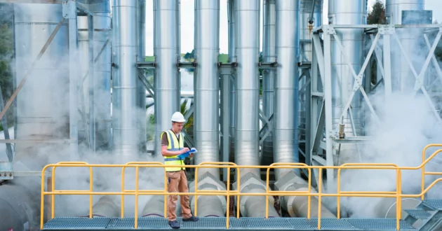
Utilities
GIS technology and geospatial data provide accurate forecasting to help utility companies better predict, plan and recover from serious weather events, minimizing power disruptions and improving restoration times. Insight into networks enables utility companies to improve operational efficiency and reliability for traditional and renewable energy sources regardless of weather conditions.
Utility companies can also run more efficiently when they understand weather-based demand patterns using location intelligence.
Further, GIS technology enables utility companies to inspect thousands of miles of power lines to ensure maximum performance. Optimizing crew schedules and shifting to proactive maintenance helps minimize downtime while increasing customer satisfaction.
Climate change
GIS technology can be an effective tool in the fight against climate change by providing a comprehensive view of current environmental issues and how they will evolve. Detailed visualizations enable organizations to monitor risks, anticipate potential issues and look for solutions.
For instance, GIS tools help scientists better understand changing weather patterns which helps governments and organizations make better strategic decisions. Intelligence-based data and satellite imagery ensure that first responders and recovery workers are where they’re needed most—and when the crisis is under control, GIS can assist in making sure structures and services are back up and running.
Additionally, as more governments and organizations seek to reduce their carbon footprint, questions like, “where is the best place to put a windfarm?” or “does this building receive enough sunlight to install solar panels?” can be answered by geospatial data and GIS.
The future of GIS
Internet of Things (IoT) connected devices, drones, cloud computing, automation and other technologies will expand the detail of geospatial data and make it more user-friendly. Additionally, virtual reality (VR) is adding a dynamic new capability: VR will allow users to walk through and interact with spatial data in exciting new ways.
Further, the integration of artificial intelligence (AI) is expanding with the development of scalable foundational models that help analyze all types of data from remote sensors. Users will be able to answer questions pertaining to specific issues including deforestation, natural disaster response, invasive species and more. You can read more about the collaboration between IBM and NASA here.
Good decisions stem from good data management
Geographic information systems help organizations make sense of seemingly disconnected datasets to better anticipate and mitigate the impact of disruptive environmental conditions. Learn how the IBM Environmental Intelligence Suite takes datasets pertaining to environmental, industry-specific shifts and more and displays them in clear, customizable dashboards for better decision-making and optimized operations.
Explore the IBM Environmental Intelligence SuiteMore from Sustainability


IBM Newsletters
Get our newsletters and topic updates that deliver the latest thought leadership and insights on emerging trends.Subscribe now More newsletters
- SEO Powered Content & PR Distribution. Get Amplified Today.
- PlatoData.Network Vertical Generative Ai. Empower Yourself. Access Here.
- PlatoAiStream. Web3 Intelligence. Knowledge Amplified. Access Here.
- PlatoESG. Carbon, CleanTech, Energy, Environment, Solar, Waste Management. Access Here.
- PlatoHealth. Biotech and Clinical Trials Intelligence. Access Here.
- Source: https://www.ibm.com/blog/geographic-information-system-use-cases/
- :has
- :is
- :where
- $UP
- 1
- 10
- 13
- 130
- 14
- 15%
- 2022
- 2023
- 27
- 28
- 29
- 30
- 300
- 39
- 400
- 41
- 9
- a
- ability
- Able
- About
- According
- accurate
- acquisition
- acres
- across
- adapt
- adding
- Additionally
- adjustments
- adopt
- advanced
- Advertising
- affecting
- again
- against
- aggregation
- AI
- alike
- All
- allow
- also
- amp
- an
- analysis
- analytics
- analyze
- and
- answer
- anticipate
- applications
- approaches
- ARE
- AREA
- areas
- around
- article
- articles
- AS
- aspect
- asset
- assist
- At
- author
- Automation
- available
- back
- BE
- been
- being
- BEST
- Better
- between
- Blog
- Blue
- both
- bring
- Building
- built
- business
- business practices
- businesses
- but
- button
- by
- california
- CAN
- capability
- carbon
- carbon footprint
- card
- Cards
- cars
- CAT
- Category
- Cells
- centered
- certain
- change
- Changes
- changing
- check
- choices
- circles
- claim
- class
- clear
- Climate
- Climate change
- Cloud
- cloud computing
- collaboration
- color
- combine
- comes
- Companies
- comprehensive
- computing
- conditions
- connected
- connected devices
- Consumers
- Container
- continue
- control
- Costs
- created
- creates
- crew
- crisis
- critical
- crop
- crops
- crucial
- CSS
- Current
- custom
- customer
- Customer satisfaction
- customizable
- dashboards
- data
- data management
- datasets
- Date
- December
- Decision Making
- decisions
- Default
- definitions
- deforestation
- Degree
- deliver
- delivery
- Demand
- Demographics
- description
- Design
- detail
- detailed
- Determine
- Development
- Devices
- different
- digital
- disaster
- disciplines
- disconnected
- discussion
- Display
- displays
- disruptions
- disruptive
- distribution
- done
- downtime
- Drones
- dynamic
- Ecosystems
- edition
- Effective
- efficiency
- efficient
- efficiently
- emerging
- employees
- enable
- enables
- encourage
- energy
- enough
- ensure
- ensures
- Enter
- Enterprise
- Environment
- environmental
- equipment
- ESG
- essential
- estate
- Ether (ETH)
- Event
- events
- evolve
- example
- examples
- exciting
- Exit
- Expand
- expanding
- extreme
- fails
- Failure
- false
- farmers
- farming
- Farms
- Features
- field
- fight
- financial
- financial performance
- Fire
- Firm
- First
- focusing
- follow
- follows
- fonts
- food
- food supply
- Footprint
- For
- forecasts
- form
- Foundation
- Foundational
- Frequency
- from
- future
- generator
- geographic
- geographical
- get
- Global
- globe
- good
- google maps
- governance
- Governments
- graphs
- Green
- Grid
- Grow
- Have
- Heading
- Health
- height
- help
- helping
- helps
- highest
- Highlighted
- How
- HTTPS
- IBM
- ICO
- ICON
- ignore
- image
- images
- Impact
- Impacts
- improve
- improving
- in
- Including
- incorporate
- Increase
- increasing
- index
- individuals
- industries
- industry-specific
- information
- Information Systems
- Initiative
- insight
- insights
- install
- instance
- instrument
- Integrating
- integration
- Intelligence
- interact
- into
- invasive
- Invest
- Investors
- iot
- issues
- IT
- ITS
- jpg
- Key
- Land
- large
- largest
- latest
- leader
- Leadership
- LEARN
- levels
- Leverage
- Life
- lifestyle
- like
- lines
- live
- local
- locale
- location
- Look
- looking
- Lot
- low-cost
- made
- maintenance
- Majority
- make
- MAKES
- Making
- manage
- management
- many
- mapping
- Maps
- Market
- Market Leader
- max-width
- maximum
- May..
- measures
- million
- min
- minimize
- minimizing
- minutes
- Mitigate
- Mobile
- models
- Monitor
- more
- more efficient
- most
- much
- Named
- Nasa
- Nations
- Natural
- Navigation
- Need
- needed
- networks
- New
- Newsletters
- nine
- nothing
- Notice..
- November
- now
- obtains
- of
- off
- often
- on
- once
- only
- open
- operational
- Operations
- opportunities
- optimal
- optimized
- optimizing
- or
- organizations
- Other
- our
- out
- outcomes
- over
- page
- panels
- particularly
- patterns
- People
- perform
- performance
- pertaining
- PHP
- Place
- placed
- placement
- plan
- planet
- planning
- plans
- plato
- Plato Data Intelligence
- PlatoData
- plugin
- points
- policy
- Pollution
- portfolio
- portfolio management
- position
- possible
- Post
- potential
- power
- practices
- predict
- predictive
- preparing
- primary
- Proactive
- produce
- Production
- productive
- programme
- projects
- provide
- provides
- providing
- put
- Questions
- quickly
- random
- Read
- Reading
- reaffirmed
- real
- real estate
- real-time
- real-time data
- Reality
- reasons
- receive
- recent
- recently
- record
- Recover
- recovery
- reduce
- reducing
- referred
- Regardless
- Relationships
- reliability
- remote
- Renewable
- renewable energy
- report
- Reporting
- representing
- research
- resolve
- resource
- Resources
- Respond
- response
- responsive
- restoration
- reuse
- risks
- robots
- ROI
- Route
- Rule
- Run
- running
- satellite
- satellite imagery
- satisfaction
- Save
- scalable
- scientists
- scores
- Screen
- scripts
- secure
- see
- Seek
- seem
- segmentation
- sense
- sensors
- seo
- serious
- service
- Services
- SHIFTING
- Shifts
- should
- Shows
- similar
- Simple
- simpler
- since
- site
- small
- Social
- Software
- soil
- solar
- solar panels
- solution
- Solutions
- Sources
- Spatial
- specific
- Sponsored
- squares
- stands
- start
- statistics
- Stem
- Strategic
- strategic business
- strategies
- streets
- structures
- subscribe
- such
- suite
- sunlight
- supply
- sure
- Surface
- Sustainability
- sustainable
- SVG
- system
- Systems
- Tablet
- takes
- Technologies
- Technology
- tertiary
- texas
- than
- that
- The
- The Initiative
- their
- Them
- theme
- then
- These
- they
- things
- think
- this
- thought
- thought leadership
- thousands
- three
- Through
- time
- times
- Title
- to
- today
- tool
- tools
- top
- topic
- traditional
- transportation
- Trends
- trip
- type
- types
- under
- understand
- United
- united nations
- Updates
- urban
- URL
- us
- use
- used
- user-friendly
- users
- uses
- using
- utility
- value
- variety
- vendors
- View
- Virtual
- Virtual reality
- visualization
- visualize
- visually
- vr
- Vulnerable
- W
- walk
- was
- Waste
- Water
- ways
- Weather
- weather patterns
- WELL
- What
- when
- which
- while
- WHO
- whose
- will
- with
- within
- woman
- WordPress
- Work
- workers
- world
- written
- yields
- you
- zephyrnet