Most navigation systems use GPS to determine where they are. GPS stands for Global Positioning System, and it is a satellite-based navigation system owned and operated by the United States Government. The European alternative is called Galileo.
These satellite-based systems have several disadvantages:
- The accuracy of GPS and Galileo is a few meters, which is fine if you are using GPS to navigate your truck or van to the address where you need to drop off your cargo, but the story changes when you want to send an autonomous drone to drop off a package somewhere.
- The signal is not very strong. The radiowaves used can easily be deflected or blocked by building, causing further inaccuracy or even complete signal loss.
- There is no backup system. If GPS is down, you will need to use a map, if you still know how to use one
Determining location by sending messages
Scientists of the Technical University of Delft, the Vrije Universiteit of Amsterdam and VSL have developed a navigation system with an accuracy of 10 centimetres. The new system is not based on satellites but uses a mobile phone infrastructure specifically designed for this project. The team connected a highly accurate atomic clock to a mobile network, creating a system that could send messages with perfect time stamps. These perfectly timed messages make it possible to accurately determine location. Because the system uses a much wider band of radio signals, it is less vulnerable when it comes to blockage or deflection.
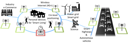
The fact that the system is so much more robust and accurate will make it perfect for navigation in urban environments. The first application that comes to mind is the distribution and delivery of goods in densely populated cities. With companies working on self-driving vehicles and drones and robots delivering items, accurate navigation and localisation are increasingly important.
“We had already been investigating techniques to distribute the national time produced by our atomic clocks to users elsewhere through the telecommunication network,” says Erik Dierikx of VSL. “With these techniques we can turn the network into a nationwide distributed atomic clock – with many new applications such as very accurate positioning through mobile networks.”
Erik Dierkx of VSL
For those of you that like to dive deeper into the technical details of this technology; here is a quote from the research team’s website:
A highly stable and accurate clock and frequency reference is distributed through an optical network using White Rabbit (WR) technology. The optical network allows for synchronization of Radio Frequency (RF) equipment across the entire network. The time-offset between radio transmitters synchronized with this network will be less than 100 picoseconds. Simultaneous transmission of radio signals into the wireless medium is actually comparable to ground-based pseudo-satellite transmissions used with the Global Positioning System (GPS). Also similar to GPS, the receiver, for instance in a vehicle on the road and hence not connected to the optical network, will synchronize its clock to the system, using the SuperGPS radio-signals, and thereby allow for highly accurate ranging.
This project aims to develop a novel hybrid optical-wireless terrestrial system for accurate positioning through a grid of radio transmitters, synchronized with extremely high accuracy through an optical telecommunication network.
https://www.tudelft.nl/citg/over-faculteit/afdelingen/geoscience-remote-sensing/research/projects/supergps/what-is-supergps
Header image by Eric Masur on Unsplash
- SEO Powered Content & PR Distribution. Get Amplified Today.
- Platoblockchain. Web3 Metaverse Intelligence. Knowledge Amplified. Access Here.
- Source: https://logisticsmatter.com/dutch-scientists-develop-supergps-with-10cm-accuracy/
- 10
- 100
- 9
- a
- accuracy
- accurate
- accurately
- across
- actually
- address
- aims
- allows
- already
- alternative
- amsterdam
- and
- Application
- applications
- autonomous
- Backup
- BAND
- based
- because
- between
- blocked
- Building
- called
- causing
- Changes
- Cities
- Clock
- Clocks
- Companies
- comparable
- complete
- connected
- could
- Creating
- credit
- deeper
- delivering
- delivery
- designed
- details
- Determine
- develop
- developed
- distribute
- distributed
- distribution
- down
- drone
- Drones
- Drop
- Dutch
- easily
- elsewhere
- Entire
- environments
- equipment
- European
- Even
- extremely
- few
- fine
- First
- Frequency
- from
- further
- Global
- goods
- Government
- gps
- Grid
- here
- High
- highly
- How
- How To
- HTTPS
- Hybrid
- image
- important
- in
- increasingly
- Infrastructure
- instance
- IT
- items
- Know
- location
- loss
- make
- many
- map
- medium
- messages
- mind
- Mobile
- mobile networks
- mobile phone
- more
- National
- Nationwide
- Navigate
- Navigation
- Need
- network
- networks
- New
- novel
- operated
- owned
- package
- perfect
- phone
- plato
- Plato Data Intelligence
- PlatoData
- populated
- positioning
- possible
- Produced
- project
- Radio
- ranging
- research
- road
- robots
- robust
- satellites
- scientists
- self-driving
- sending
- several
- Signal
- signals
- similar
- So
- somewhere
- specifically
- stable
- stands
- States
- Still
- Story
- strong
- such
- synchronization
- system
- Systems
- team
- Technical
- techniques
- Technology
- telecommunication
- terrestrial
- The
- thereby
- Through
- time
- Timed
- to
- transmitters
- truck
- TURN
- United
- United States
- university
- urban
- use
- users
- vehicle
- Vehicles
- Vulnerable
- webp
- Website
- which
- white
- wider
- will
- wireless
- working
- Your
- zephyrnet