Join us for a captivating conversation in the episode 5 of podcast series “Open Geo AI: Unveiling Satellite Insights through Open Data.”
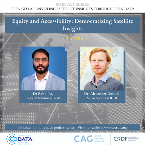 Episode 5 – Equity and Accessibility: Democratising Satellite Insights
In this podcast on Equity and Accessibility: Democratising Satellite Insights, speakers Rahul Raj and Alexander Dunkel delve into the ethical considerations of open data policies, ensuring equitable access to satellite information, and its crucial role in closing global information gaps. They also discuss how we leverage social media data for ground truth analysis.
Dr Rahul Raj is the Principal research scientist at Pixxel, a satellite manufacturing and data analytics company. Dr Rahul leads the image processing team at Pixxel. He is working in the field of remote sensing, where he has gathered in-depth experience in low-altitude drone-based and high-altitude satellite-based earth observation. His research vision is to lead socially relevant and environment-friendly research programs to impact the current and upcoming generations positively.
Alexander Dunkel is a Senior Scientist at IOER in Dresden, Germany, working at the interface between the Research Data Centre (RDC) and the Transformative Capacities lab (FBT). As a data engineer with a landscape and environmental planning background, Alex sees himself as a link between application-oriented disciplines and fundamental data research. In 2016, Alexander received his PhD from the University of Technology in Dresden with a dissertation focusing on the intersection of crowdsourced data and landscape perception. He then joined the Faculty of Environmental Sciences for the DFG Priority Program „Volunteered Geographic Information: Interpretation, Visualisation and Social Computing“. In his recent work, Alexander has focused on developing integrated solutions for more equitable public participation and decision-making using open-source technology. Alexander has given workshops and presentations on data visualisation at national and international institutions, including the University of Waterloo, the University of Toronto, the UC Berkeley, and the CCA in San Francisco.
https://crdf.org.in/podcast/open-geo-ai-unveiling-satellite-insights-through-open-data
Watch all episodes here: https://codata.org/initiatives/data-skills/codata-connect/open-geo-ai-unveiling-satellite-insights-through-open-data-podcast-series/
- SEO Powered Content & PR Distribution. Get Amplified Today.
- PlatoData.Network Vertical Generative Ai. Empower Yourself. Access Here.
- PlatoAiStream. Web3 Intelligence. Knowledge Amplified. Access Here.
- PlatoESG. Carbon, CleanTech, Energy, Environment, Solar, Waste Management. Access Here.
- PlatoHealth. Biotech and Clinical Trials Intelligence. Access Here.
- Source: https://codata.org/crdf-and-codata-podcast-series-open-geo-ai-new-episode-available-2/
- :has
- :is
- :where
- 2016
- 5
- 500
- a
- access
- accessibility
- AI
- alex
- Alexander
- All
- also
- analysis
- analytics
- and
- AS
- At
- background
- Berkeley
- between
- capacities
- captivating
- centre
- closing
- CODATA
- committee
- company
- considerations
- Conversation
- crucial
- Current
- data
- Data Analytics
- data centre
- data engineer
- data research
- data visualisation
- Decision Making
- delve
- developing
- disciplines
- discuss
- dr
- earth
- engineer
- ensuring
- environmental
- episode
- Episodes
- equitable
- equity
- ethical
- experience
- field
- focused
- focusing
- For
- Francisco
- from
- fundamental
- gaps
- gathered
- generations
- geographic
- Germany
- given
- Global
- Ground
- he
- here
- himself
- his
- How
- HTTPS
- image
- Impact
- in
- in-depth
- Including
- information
- insights
- institutions
- integrated
- Interface
- International
- interpretation
- intersection
- into
- ITS
- joined
- lab
- landscape
- lead
- Leads
- Leverage
- LINK
- manufacturing
- max-width
- Media
- more
- National
- New
- observation
- of
- on
- open
- open data
- open source
- participation
- perception
- phd
- planning
- plato
- Plato Data Intelligence
- PlatoData
- podcast
- policies
- positively
- Presentations
- Principal
- priority
- processing
- Program
- Programs
- public
- received
- recent
- relevant
- remote
- research
- research programs
- Role
- San
- San Francisco
- satellite
- Science
- Science and Technology
- SCIENCES
- Scientist
- sees
- senior
- Series
- Social
- social media
- socially
- Solutions
- speakers
- team
- Technology
- The
- then
- they
- this
- Through
- to
- toronto
- transformative
- truth
- university
- unveiling
- upcoming
- us
- using
- vision
- we
- with
- Work
- working
- Workshops
- zephyrnet