GeoCue has announced that Acecore Technologies, the European designer and manufacturer of professional UAV systems, has joined its list of accepted drone providers for integrating its TrueView 3D Imaging Sensors.
As part of GeoCue’s commitment to providing customers with complete drone mapping solutions, this partnership with Acecore opens new possibilities for aerial data collection in Europe.
Acecore leverages its drone platform to accommodate additional hardware and functionalities according to specific customer requirements.
GeoCue is known for its ability to modify and integrate LiDAR technology with advanced sensors, while customising the software for high-quality deliverables.
Together, this partnership takes customisation to new heights, as TrueView payloads are now seamlessly integrated with the Acecore platform. This enables customers to overcome aerial surveying challenges by enhancing their capability to collect precise aerial data. Furthermore, both companies’ welcome client feedback for additional functionality based on any unique projects or challenges.
Acecore Technologies’ handcrafted, full carbon fibre drones cater to a diverse range of applications, including LiDAR, mapping, inspection, security and creative solutions. With a mission to revolutionise the commercial drone airspace, Acecore aims to make a significant impact on the drone industry with its professional elevated drones.
“At Acecore, we take pride in producing the highest quality turnkey industrial UAV solutions,” says Jorrit Linders, CEO of Acecore Technologies. “All our drones are meticulously handcrafted in the Netherlands, using only the finest materials available. Drawing from our background in high-end cinematography, we are dedicated to developing the most stable platforms with zero margin for error.”
Acecore’s fleet of professional drones comprises three main platforms – Zoe, Noa and Neo. Each drone boasts distinct features in terms of size, price, and configuration, catering to a wide range of industries and applications. Whether it’s large-scale mapping projects, intricate inspections, or creative endeavors, Acecore’s drones provide versatile solutions for every user’s needs.
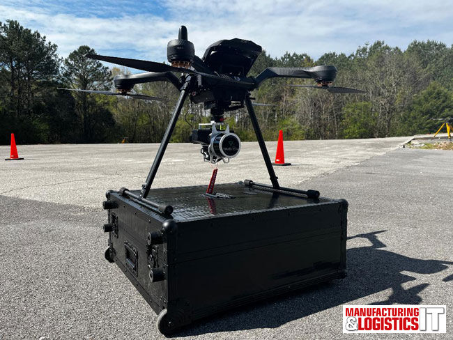
Off the shelf, Acecore’s drones offer high-end performance in difficult circumstances due to its reliable propulsion systems, offering motor redundancy on every platform. The real time flight performance is further improved by the use of F9P L1/L2 receiving GPS pucks with the option to upgrade to a dual GPS setup for accurate heading correction. TrueView 3D Imaging Sensors are housed securely on Acecore’s industry standard payload bay, offering optimised vibration isolation to the TrueView’s intricate IMU.
Vincent Legrand, Vice President of Global Sales for GeoCue, is pleased to add Acecore as an integrated drone provider. “With the integration of Acecore’s drone platforms now available for TrueView 3D Imaging Systems, we can now offer our European customers the top options for conducting aerial surveys, mapping, and data collection.”
He adds: “GeoCue is dedicated to working with leading drone providers like Acecore to empower our customers with cutting-edge technologies and solutions. The addition of Acecore to our list of accepted drone manufacturers is a testament to our commitment to providing the most comprehensive and innovative drone mapping solutions in the industry.”
- SEO Powered Content & PR Distribution. Get Amplified Today.
- PlatoData.Network Vertical Generative Ai. Empower Yourself. Access Here.
- PlatoAiStream. Web3 Intelligence. Knowledge Amplified. Access Here.
- PlatoESG. Automotive / EVs, Carbon, CleanTech, Energy, Environment, Solar, Waste Management. Access Here.
- PlatoHealth. Biotech and Clinical Trials Intelligence. Access Here.
- ChartPrime. Elevate your Trading Game with ChartPrime. Access Here.
- BlockOffsets. Modernizing Environmental Offset Ownership. Access Here.
- Source: https://www.logisticsit.com/articles/2023/08/31/acecore-joins-geocue-integrated-drone-platforms-for-trueview-3d-lidar-imaging-and-mapping
- :has
- :is
- 3d
- a
- ability
- accepted
- accommodate
- According
- accurate
- add
- addition
- Additional
- Adds
- advanced
- aims
- airspace
- All
- an
- and
- announced
- any
- applications
- ARE
- AS
- At
- available
- background
- based
- Bay
- boasts
- both
- by
- CAN
- capability
- carbon
- cater
- ceo
- challenges
- cinematography
- circumstances
- client
- collect
- collection
- commercial
- commitment
- complete
- comprehensive
- comprises
- conducting
- Configuration
- Creative
- customer
- Customers
- cutting-edge
- Cutting-Edge Technologies
- data
- dedicated
- Designer
- developing
- difficult
- distinct
- diverse
- drawing
- drone
- Drones
- due
- each
- elevated
- empower
- enables
- endeavors
- enhancing
- error
- Ether (ETH)
- Europe
- European
- Every
- Features
- feedback
- FLEET
- flight
- For
- from
- full
- functionalities
- functionality
- further
- Furthermore
- Global
- gps
- Hardware
- Heading
- heights
- High-End
- high-quality
- highest
- HTTPS
- Imaging
- Impact
- improved
- IMU
- in
- Including
- industrial
- industries
- industry
- innovative
- integrate
- integrated
- Integrating
- integration
- isolation
- IT
- ITS
- joined
- Joins
- jpg
- known
- large-scale
- leading
- leverages
- lidar
- like
- List
- Main
- make
- Manufacturer
- Manufacturers
- mapping
- Margin
- materials
- meticulously
- Mission
- modify
- most
- Motor
- needs
- NEO
- Netherlands
- New
- now
- of
- offer
- offering
- on
- only
- opens
- Optimised
- Option
- Options
- or
- our
- Overcome
- part
- Partnership
- performance
- platform
- Platforms
- plato
- Plato Data Intelligence
- PlatoData
- pleased
- possibilities
- precise
- president
- price
- pride
- producing
- professional
- projects
- propulsion
- provide
- provider
- providers
- providing
- quality
- range
- real
- real-time
- receiving
- reliable
- Requirements
- s
- sales
- says
- seamlessly
- securely
- security
- sensors
- setup
- Shelf
- significant
- Size
- Software
- Solutions
- specific
- stable
- standard
- Systems
- Take
- takes
- Technologies
- Technology
- terms
- testament
- that
- The
- the Netherlands
- their
- this
- three
- time
- to
- top
- turnkey
- UAV
- unique
- upgrade
- use
- User
- using
- versatile
- vice
- Vice President
- we
- welcome
- whether
- while
- wide
- Wide range
- with
- working
- zephyrnet
- zero