Unlocking the power of geospatial data can give organizations a competitive edge, from optimizing supply chain logistics and enhancing customer experience to mitigating fraud and improving public health outcomes. But despite its far-reaching benefits, many organizations fail to fully harness geospatial data’s potential.
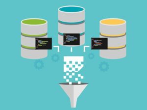
Why? Because geospatial data is voluminous, complex, and often distributed across multiple sources. As a result, geospatial data requires expert knowledge to clean, access, analyze and, most importantly, display and prepare for wider consumption.
However, many organizations lack the in-house skills and resources to process geospatial data. And data experts that do have the knowledge simply don’t have enough time in their days to spend on geospatial analysis.
But there’s good news, and it starts with making geospatial data more accessible to the entire organization. By removing the coding barrier and providing training, organizations can take full advantage of geospatial data and ensure employees put it to good use. When every employee is trained to handle and interpret geospatial data, departments across the organization reap the benefits.
Challenges Limit Organizations from Using Geospatial Data to Its Full Potential
Geospatial data is challenging to store due to its sheer volume and complexity, making it time-consuming to find and access the data employees need. It also requires specialized knowledge to interpret and analyze. But with the majority of data scientists’ days already spent on data-curation activities, data scientists have to be extremely efficient to maximize their use of geospatial data – which is easier said than done. Additionally, many geospatial analysis tools are expensive and/or require coding skills, which limits access to insights and makes it difficult to scale.
These challenges restrict most organizations from using geospatial data to its full potential. But when organizations adopt a low-code tool with geospatial analytics capabilities and provide the appropriate training to employees, they create new possibilities for geospatial analytics, without overwhelming their data experts.
In this approach, a central team of expert data scientists still performs the upfront work of sourcing and importing the data, as well as running trainings and maintenance on the system. By eliminating some coding barriers, ad hoc analytics becomes affordable and accessible to every employee, regardless of title. And once an employee is trained to interpret insights, they can start taking advantage of geospatial data for their team.
3 Use Cases of Geospatial Data for Your Organization
Geospatial data has applications for nearly every department in your organization. With a low-code tool, you can reduce the burden on your data science teams, help marketers better target messaging, and enable your IT team to enhance the organization’s security posture.
Here are just some of the use cases that are possible when you make geospatial data accessible to the entire organization:
1. Marketing departments
Geospatial data expands the reach of your organization. It can help your marketing teams optimize campaigns, increase engagement, and make more informed decisions about marketing strategies. With geospatial data, marketers can more effectively segment their audiences, target specific locations, analyze competition, and monitor data in real time to increase impact.
For example, if you’re a retail organization looking to expand your physical footprint, geospatial data can help identify potential locations for new stores or branches based on factors like population density, demographic information, and potential for foot traffic. After a store opens, your marketing teams can also use geospatial data to create more personalized offers for local customers.
2. Operations departments
For operations teams, geospatial data is critical for optimizing workflows and reducing costs. These insights help your teams enhance routes, track assets (e.g., vehicles and equipment), and identify potential sites for new facilities. Geospatial data can also help you predict maintenance needs to reduce downtime, more effectively respond to natural disasters and allocate resources.
Let’s say you’re a manufacturing operation. You could use geospatial data to track the location of raw materials, monitor the status of orders as they move through the supply chain, and identify bottlenecks or inefficiencies in the process. Geospatial data can even identify discrepancies in the services you provide across geographies so you can refine your products and services.
3. IT teams
By enabling your IT teams to better manage IT infrastructure and systems with a low-code geospatial analytics tool, you can boost your entire organization’s security posture. Geospatial data insights can help your IT team plan for disaster recovery, monitor energy consumption, and keep tabs on IT assets (e.g., laptops and mobile devices) to prevent theft or loss.
For example, your IT teams might use geospatial data to plot network traffic on a map and quickly identify geographic regions that are producing large volumes of traffic or connections, exposing potential security threats. Geospatial data can also identify anomalies, like if a device suddenly starts communicating with a server in a foreign country, which could indicate it’s been compromised. With these insights, your teams can more quickly react and mitigate threats.
These are just a few examples – in practice, departments across all organizations can benefit from geospatial data.
Unlock Geospatial Data Use Cases for Your Teams
Geospatial data is becoming increasingly important to all organizations. But without the necessary time and support, it’s often expensive and challenging for data teams to wrangle and analyze. However, with the right tools and training, you can enable every employee to understand geospatial data and gain valuable insights for their teams – reducing the lift for data scientists and driving efficiencies across the organization.
- SEO Powered Content & PR Distribution. Get Amplified Today.
- PlatoAiStream. Web3 Data Intelligence. Knowledge Amplified. Access Here.
- Minting the Future w Adryenn Ashley. Access Here.
- Buy and Sell Shares in PRE-IPO Companies with PREIPO®. Access Here.
- Source: https://www.dataversity.net/why-geospatial-data-should-be-easily-accessible-for-every-employee/
- :has
- :is
- a
- About
- access
- accessible
- across
- Ad
- Additionally
- adopt
- ADvantage
- affordable
- After
- All
- already
- also
- an
- analysis
- analytics
- analyze
- and
- applications
- approach
- appropriate
- ARE
- AS
- Assets
- audiences
- barrier
- barriers
- based
- BE
- because
- becomes
- becoming
- been
- benefit
- benefits
- Better
- boost
- branches
- burden
- but
- by
- Campaigns
- CAN
- capabilities
- cases
- central
- chain
- challenges
- challenging
- Coding
- communicating
- competition
- competitive
- complex
- complexity
- Compromised
- Connections
- consumption
- Costs
- could
- country
- create
- critical
- customer
- customer experience
- Customers
- data
- data science
- DATAVERSITY
- Days
- decisions
- demographic
- density
- Department
- departments
- Despite
- device
- Devices
- difficult
- disaster
- disasters
- Display
- distributed
- do
- done
- Dont
- downtime
- driving
- due
- e
- easier
- easily
- Edge
- effectively
- efficiencies
- efficient
- eliminating
- Employee
- employees
- enable
- enabling
- energy
- Energy Consumption
- engagement
- enhance
- enhancing
- enough
- ensure
- Entire
- equipment
- Even
- Every
- example
- examples
- Expand
- expands
- expensive
- experience
- expert
- experts
- extremely
- facilities
- factors
- FAIL
- far-reaching
- few
- Find
- Foot
- Footprint
- For
- foreign
- fraud
- from
- full
- fully
- Gain
- geographic
- geographies
- Give
- good
- handle
- Have
- Health
- help
- However
- HTTPS
- identify
- if
- Impact
- important
- importing
- improving
- in
- Increase
- increasingly
- indicate
- information
- informed
- Infrastructure
- insights
- IT
- ITS
- jpg
- just
- Keep
- knowledge
- Lack
- laptops
- large
- like
- LIMIT
- limits
- local
- location
- locations
- logistics
- looking
- loss
- maintenance
- Majority
- make
- MAKES
- Making
- manage
- manufacturing
- many
- map
- marketers
- Marketing
- Marketing Strategies
- materials
- Maximize
- messaging
- might
- Mitigate
- mitigating
- Mobile
- mobile devices
- Monitor
- more
- most
- move
- multiple
- Natural
- nearly
- necessary
- Need
- needs
- network
- network traffic
- New
- news
- of
- Offers
- often
- on
- once
- opens
- operation
- Operations
- Optimize
- optimizing
- or
- orders
- organization
- organizations
- outcomes
- performs
- Personalized
- physical
- plan
- plato
- Plato Data Intelligence
- PlatoData
- population
- possibilities
- possible
- potential
- power
- practice
- predict
- Prepare
- prevent
- process
- Products
- Products and Services
- provide
- providing
- public
- public health
- put
- quickly
- Raw
- reach
- React
- real
- real-time
- recovery
- reduce
- reducing
- refine
- Regardless
- regions
- removing
- require
- requires
- Resources
- Respond
- restrict
- result
- retail
- right
- routes
- running
- Said
- say
- Scale
- Science
- scientists
- security
- Security threats
- segment
- Services
- should
- simply
- Sites
- skills
- So
- some
- Sources
- Sourcing
- specialized
- specific
- spend
- spent
- start
- starts
- Status
- Still
- store
- stores
- strategies
- supply
- supply chain
- support
- system
- Systems
- Take
- taking
- Target
- team
- teams
- than
- that
- The
- theft
- their
- These
- they
- this
- threats
- Through
- time
- time-consuming
- Title
- to
- tool
- tools
- track
- traffic
- trained
- Training
- trainings
- understand
- use
- using
- Valuable
- Vehicles
- volume
- volumes
- WELL
- when
- which
- why
- wider
- with
- without
- Work
- workflows
- you
- Your
- zephyrnet